Separating the ACE Hurricane Index into Number, Intensity, and Duration
Copyright 2007 by Carl Drews
Published on the Internet: August 24, 2007
The ACE (Accumulated Cyclone Energy) hurricane index is a product of three factors that can reveal the changing character of hurricane activity.
Abstract
The ACE hurricane index (Accumulated Cyclone Energy) uses the maximum wind speed over time to quantify hurricane activity by season. The ACE index ranks the 2005 Atlantic season as one of the most active on record. Three measures of hurricane activity are often identified: intensity, duration, and number of storms. The author asserts that the ACE formulation is a combination of these three measures, and demonstrates how to separate these three factors from the combined ACE and analyze them separately. The results show that the recent increase in Atlantic hurricane activity is primarily due to an increase in the number of storms per season, with increased hurricane intensity playing a secondary role.
Affiliation:
Drews - Department of Atmospheric and Oceanic Sciences, University of Colorado at Boulder; and Atmospheric Chemistry Division, National Center for Atmospheric Research, Boulder, Colorado.
Background
A hurricane's path describes a journey through meteorological space-time. From its genesis region, the cyclone intensifies over warm ocean water and churns westward with the trade winds. The hurricane dissipates heat, cools the ocean, and showers the earth's surface with rain. The storm may pass into higher latitudes, drift into the westerlies, and make landfall, where it weakens and eventually dissipates. This entire sequence of weather events represents the hurricane's activity during its lifetime. A record of many hurricanes, over one season or many, constitutes the climatology of hurricanes.
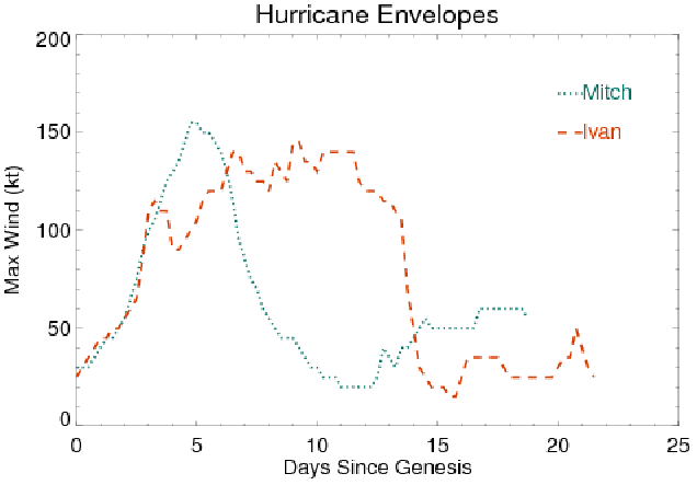
A hurricane's envelope may be thought of as a time series of the maximum wind speed within the storm, as measured at the eyewall (Landsea et al. 2006). Several organizations maintain on-line archives of storm tracks, and these archives may be used to analyze historical hurricanes. Figure 1 shows the envelopes for hurricanes Mitch in 1998 and Ivan in 2004. The tropical cyclone reports were obtained from the National Hurricane Center (2007).
Figure 1. Hurricane envelopes for Mitch (1998) and Ivan (2004).
Although Mitch and Ivan were both rated as Category 5 hurricanes on the Saffir-Simpson scale, it is evident from Figure 1 that their envelopes reveal some important differences. Mitch lasted only a few days at peak intensity, then maintained low-level winds for a sustained period. Ivan's high-intensity phase lasted about ten days. The two wind profiles in Figure 1 describe markedly different pictures of storm activity. Classifying them only as "two Category 5 hurricanes" loses valuable information. This author believes that although the Saffir-Simpson scale is a useful classification for conveying information to the general public, assigning a single integer (1-5) to each hurricane is not a good basis for further analysis.
A hurricane's envelope depicts the intensity of the storm's maximum winds and the duration of that intensity. The area under the curve is a representation of storm's total activity during its lifetime. By this measure Hurricane Ivan produced considerably more storm activity (1,712.5 knot-days) than Hurricane Mitch (1,208.75 knot-days). A hurricane season's activity is calculated by summing the activity of all the storms that occurred during that season.
A number of researchers have employed cyclone indexes based on storm intensity and duration. Emanuel (2005) noted that the monetary loss of windstorms should be related to the cube of the wind speed over the total storm area. The storm area is difficult to calculate because historical records of hurricanes do not usually include the storm dimensions. It would be very useful to have some measure of cyclone size included with storm tracks, even if it were only the radius of maximum winds. Emanuel defined a simplified power dissipation index as the sum of the cubes of the maximum wind speed for the duration of the cyclone:
Power
Dissipation Index (PDI) =
![]() (1)
(1)
Although this index is not perfect, he noted that the PDI "is a better indicator of tropical cyclone threat than storm frequency or intensity alone." Emanuel (2005) referred to Camargo and Sobel (2005), who employed an index of Accumulated Cyclone Energy (ACE) for correlating cyclone activity with El Niño Southern Oscillation (ENSO). ACE was defined by Bell et al. (2000) as the sum of the squares of the maximum wind speeds at 6-hour intervals, while the hurricane is at tropical storm strength or greater:
Accumulated
Cyclone Energy (ACE) =
![]() (2)
(2)
Bell (2000) referred to the ACE as the Hurricane Destruction Potential (HDP) index, noting that "This index represents a single, continuous distribution that implicitly accounts for numbers of hurricanes, yet also gives more weight to strong systems and long-lasting systems." He credited William M. Gray and colleagues (1999, personal communication) for prior use of the HDP index.
Webster et al. (hereafter WHCC 2005) used a number of measures to distinguish between the number of tropical storms and their intensity, but declined to multiply the storm duration by the maximum wind speed as others had done. They calculated "storm days", representing the number of days that a tropical cyclone spends at tropical storm strength or greater:
Storm
days =
![]() (3)
(3)
WHCC (2005) noted that "there is a substantial decadal-scale oscillation that is especially evident in the number of tropical cyclone days." The running average of storm-days peaks in about 1995.
This author used a floating-point version of the Saffir-Simpson scale to calculate hurricane category-days in an earlier formulation of this analysis. The resulting formulation represented the hurricane wind flux, and captured the air transport within a hurricane:
Hurricane
flux index =
![]() (4)
(4)
Analysis of the Exponent
Equations (1) through (4) may be expressed by the same general formulation:
Hurricane
index =
![]() (5)
(5)
N is the exponent by which the maximum wind speed is raised. Table 1 summarizes the range of exponents used by various researchers.
Table 1. Hurricane indexes by exponent of the maximum wind speed.
|
Exponent |
Meaning |
Index Name(s) |
Used by |
|
0 |
Duration |
Storm days |
Webster, Holland, Curry, Chang |
|
1 |
Flux |
Category-days |
Drews |
|
2 |
Kinetic Energy |
ACE, HDP |
Gray, Bell, Camargo, Sobel |
|
3 |
Power Dissipation |
PDI |
Emanuel |
The index by season takes the sum of all tropical storms during that year:
Season
index =
![]() (6)
(6)
The researchers in Table 1 chose an exponent value based on the particular needs of their project. However, this analysis seeks a general-purpose methodology in order to capture best the climatological concept of "hurricane activity." Figure 2 shows a visual comparison of global hurricane activity, using four values of the exponent N in equation 6. This exponent range assigns a different weight to the intensity of the cyclone's maximum winds. Tropical cyclone reports were obtained from NHC (2007) and the Joint Typhoon Warning Center (2007). Schreck (2006) provided formatted files of best tracks.
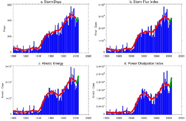
Figure 2. Recorded global tropical cyclone activity, 1900-2004. Parts a-d represent the exponent (0-3) of the maximum wind speed. The red line is a running 11-year average, and the green line is a shortened average.
This analysis is primarily concerned with hurricane metrics, not with the accuracy of the historical record. Nevertheless, it is obvious from Figure 2 that there was a sharp increase in cyclone measurement after World War II, due to increased aerial reconnaissance. These measurement artifacts help to highlight how an index can detect and display real changes in the more reliable (later) portion of the archive.
The four panels of Figure 2 display the same phases of activity: a peak in about 1960, followed by a later peak in 1995. However, note that the slope of the running average between 1960 and 1975 has changed sign between 6(a) and 6(c). The peak in 1995 and the end of the series in 2004 have changed heights relative to each other. If we were simply raising a set of constant values to the powers 0-3 we would expect to see some exaggeration in the peaks and valleys, but no exchange of height between the different portions of the curve. Instead, we see changes in slope and relative height. The sequence in Figure 2(a-d) indicates that hurricane intensity is playing a changing role in the global climatology of hurricanes.
The author used an exponent value of 2 for the remainder of the analysis. Squaring the wind speed produces a reasonable measure of hurricane energy, and provides a compromise between the low- and high-order weights given in Table 1. Note that the Figures 2(c) and 2(d) are qualitatively the most similar.
The National Oceanic & Atmospheric Administration uses the Accumulated Cyclone Energy (ACE) index to quantify hurricane activity by season. "The ACE index is a wind energy index, defined as the sum of the squares of the maximum sustained surface wind speed (knots) measured every six hours for all named systems while they are at least tropical storm strength." (NOAA 2007) The units of ACE are usually given in 104 knot2. The 6-hour measurement intervals are implicit in the ACE index, and the author believes this formulation is wrong.
The author prefers to express the ACE index in knot2-days for three reasons:
1. to emphasize that the ACE is the integral of a time series.
2. to employ a standard unit of time (days).
3. to facilitate the use of time series that are not expressed in regular 6-hour steps (such as model output).
To convert knot2-days to the NOAA formulation of ACE, multiply by 4.
ACE in the North Atlantic
Figure 3 shows the recorded activity of tropical cyclones in the North Atlantic basin. The red line is a running 11-year average. The green line also represents a multi-year average, but the averaging window is shortened on both ends toward the end of the series. For example, the averaged index value for 2004 is the average of the five years 2002-2006. The last point (2006) is not averaged. The green line is statistically less valid than the red line, but it preserves any trends in the final portion of the time series.
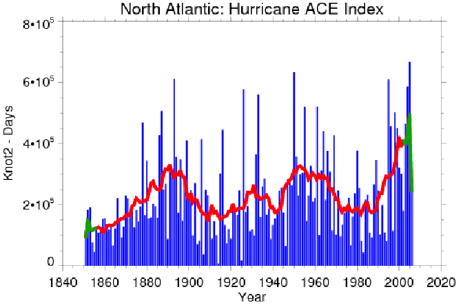
Figure 3. Recorded North Atlantic tropical cyclone activity, 1851-2006.
A remarkable feature of the North Atlantic archive is how complete it appears to be. The data from the 1850s and 1860s shows no obvious sparseness compared with data from the twentieth century; there are no sudden jumps as we see in Figure 2. These earliest cyclone tracks were prepared manually from synoptic weather maps (Barry and Carleton 2001). There are measurement problems in the first few decades of the archive, but they are not immediately visible from the ACE index alone.
Some Speculation Regarding Global Warming
Figure 3 shows the presence of a multi-decadal oscillation during the nineteenth and twentieth centuries. Goldenberg et al. (2001) and NOAA (2005) have suggested that the recent upsurge in hurricanes is a continuing part of this natural cycle, and is not due to global warming. Figure 3 contains qualitative evidence contrary to this assertion:
1. The first two peaks at 1890 and 1955 have a roughly 65-year span between them, suggesting that the third peak is not due to arrive until about 2020.
2. The increase in the running average between 1980 and 2000 is more abrupt than the previous 20-year increases before the 1890 and 1955 peaks.
3. Even if we take the last valid value of the running average in 2001 (390 x 103 knot2-days), this value is about 18% higher than the height of the previous peaks at 1891 (332 x 103) and 1953 (327 x 103).
Based on these three visual observations, it is probable that some factor other than the natural variability displayed in the previous two peaks is playing an additional role in the most recent increase in tropical cyclone activity. Global warming is a possibility. Further analysis is needed to quantify this relationship.
Separating the ACE Into Components
If one accepts that equation (6) is a reasonable expression of hurricane activity, then the total activity may be expressed as a product of three factors:
Season activity = number of storms * duration * intensity (7)
The current discussion over hurricanes has questioned the interplay of these factors: are storms becoming more numerous, longer lived, or more intense? By extracting the three individual factors of equation (7), we can illuminate this issue. A simplified hurricane season would appear like Figure 4.
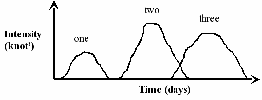
Figure 4. Simplified season with three hurricanes.
The ACE index is the total area under the three envelopes in Figure 4. The small overlap between storms two and three is double-counted. To separate the three factors in equation (7), it is useful to consider the same hurricane season in terms of quantities that represent the seasonal average.
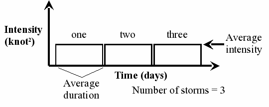
Figure 5. Simplified season with three averaged hurricanes.
In Figure 5 the three identical "average storms" have the same duration and uniform intensity, but the area under their combined envelopes is the same as in Figure 4. We can use Figure 5 to characterize each hurricane season in the North Atlantic archive. The number of storms in a single season is simply the count from the best tracks archive during that calendar year. The average duration is the mean storm lifetime in days, from the time it achieves tropical storm strength until the maximum winds fall below that threshold (minus any low-intensity gaps). The average intensity is the mean intensity of all cyclone observations in that year. According to equation (7), the product of these three factors equals the ACE index for that year. Graphing these factors individually, we obtain Figures 6, 7, and 8.
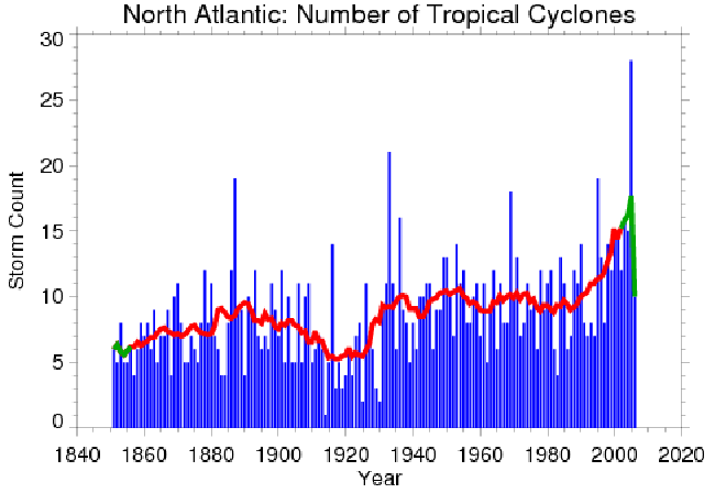
Figure 6. North Atlantic number of tropical cyclones, 1851-2006.
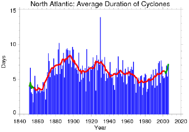
Figure 7. Average duration of North Atlantic cyclones, 1851-2006.
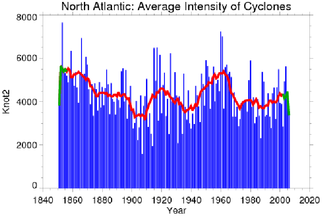
Figure 8. Average intensity of North Atlantic cyclones, 1851-2006.
If we turn our attention to the beginning of the archive, where we know there are measurement errors, it is evident from Figure 7 that the average duration of tropical cyclones during the period 1850-1870 is suspiciously low. Less evident is a corresponding period of apparent high intensity in Figure 8. These anomalies are due to incomplete storm tracks. For example, the year 1855 contains a single observation of storm 3 on August 11 at 1200, with a maximum wind speed of 70 knots. It is unlikely that this system was merely a tropical depression 6 hours earlier and 6 hours later, but we have no other data here. From these measurement artifacts we can see that separating the ACE index into its factors reveals features that are not evident in the combined index.
We believe that the end of the archive is most reliable, and we can use the ACE decomposition there to obtain values for the three factors in equation (7). Taking the interval 1990-2001 as an illustration, Table 2 shows the changes calculated from the 11-year running averages. (The factor changes are calculated horizontally; the columns do not multiply vertically to give the ACE index because they are running averages of the time series.)
Table 2. Changes in North Atlantic cyclone activity, 1990-2001.
|
|
1990 |
2001 |
Factor change |
|
Number |
10 |
14.36 |
1.44 |
|
Duration |
5.24 |
6.16 |
1.18 |
|
Intensity |
3791.02 |
4280.72 |
1.13 |
|
ACE index |
217218.68 |
389749.43 |
1.79 |
Table 2 indicates that the primary factor in the recent increase in hurricane activity is due to the increased number of tropical cyclones, with increased duration and intensity playing secondary roles. This result appears to be at odds with IPCC (2007), which focuses on increased intensity. The author welcomes clarification of this matter when the full IPCC report is released.
Western North Pacific
Figure 9 shows the ACE index in the Western North Pacific Ocean, as measured by the Joint Typhoon Warning Center (2007). West Pacific cyclone activity can be described as an upward trend from 1978 through 1992, then a stable period punctuated by a three-year lull from 1998-2000. The period of relative quiet in 1998-2000 corresponded with La Niña conditions in the equatorial Pacific (Camargo and Sobel 2005).
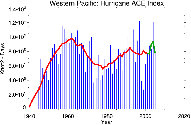
Figure 9. Western North Pacific tropical cyclone activity, 1945-2005.
The three components of the West Pacific ACE index are shown in Figures 10-12. Western Pacific trends since 1990 (as shown by the 11-year running average in red) are not as dramatic as they are in the North Atlantic basin. Nevertheless, we may observe that the JTWC record shows a slight increase in intensity since 1990. Number and duration of storms have fallen to produce an overall decline in the ACE index since 1992. Note that although the number and duration of storms were influenced by the 1998-2000 La Niña event (as noted by Wang and Chan 2002), the cyclone intensity during that period was less affected.
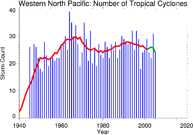
Figure 10. Western North Pacific number of tropical cyclones, 1945-2005.
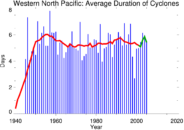
Figure 11. Average duration of Western North Pacific cyclones, 1945-2005.
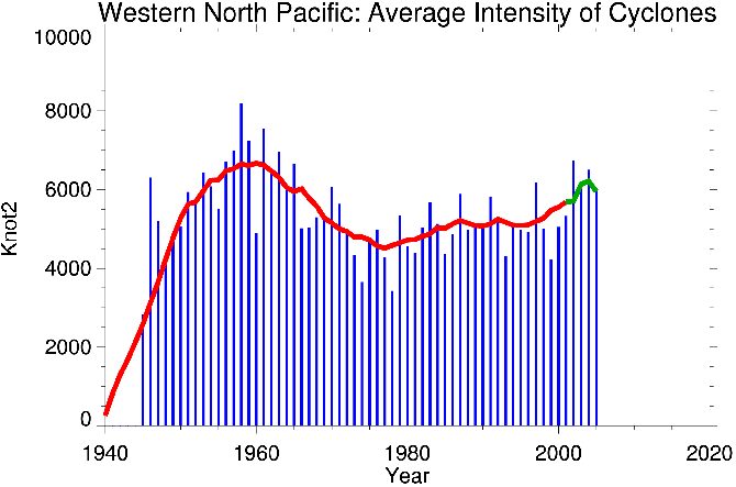
Figure 12. Average intensity of Western North Pacific cyclones, 1945-2005.
Wu et al. (2006) raised questions about differences in typhoon intensity between datasets of the JTWC, the Regional Specialized Meteorological Centre (RSMC) in Tokyo, Japan, and the Hong Kong Observatory (HKO) in Hong Kong, China. They attribute the difference in wind speeds to 1-minute averaging intervals used by JTWC, versus 10-minute averages used by RSMC and HKO. Use of a Dvorak technique is another difference. Kossin et al. (2007) also investigated the West Pacific basin, and suggested that the JTWC best tracks may be introducing a long-term upward trend in typhoon intensity. Separating the ACE into its components here would determine if the discrepancy in ACE is due to differences in maximum wind speed alone, or if storm duration is also involved. Note that since wind speed affects the threshold at which a tropical depression becomes a named tropical storm, intensity and duration are not completely independent.
Conclusion
The ACE hurricane index is a valuable metric for quantifying the overall impact of tropical cyclones on the earth's climate. The method of calculating the index does not depend on 6-hour intervals, but can be scaled to finer resolution datasets and model output. The ACE index can be separated into number of storms, duration, and intensity by recognizing that the accumulated cyclone energy is a duration-based integral of a time series. Separating the ACE index into its components reveals characteristics that are not evident in the combined index. The individual factors indicate that increased numbers of tropical cyclones are primarily responsible for the recent increase in North Atlantic hurricane activity, with duration and intensity playing secondary roles.
The increase in North Atlantic cyclone activity from 1990 to 2001 appears visually to be too soon, too abrupt, and too great to be explained by natural multi-decadal variability alone. The current trend differs markedly from the previous two cycles. Regional warming is a possible contributor. The author hopes to quantify this anomaly in a follow-up analysis. Future research will focus on correlating the components of the ACE index with sea surface temperature.
Additional On-line Material
To download processed data, hurricane envelopes, and storm tracks for display with Google EarthTM, please visit the author's web site:
https://webfiles.colorado.edu/drewsc/www/hurricane/
Corresponding Author:
Carl Drews
3450 Mitchell Lane
Boulder, CO 80301
E-mail: carl.drews@colorado.edu
Acknowledgments
The author is grateful for discussions in class with Professor Roger Barry, Marcia Wyatt, Betsy Forrest, Matthew Shupe, Tiffany Duhl, Eungul Lee, and Julie Malmberg at the University of Colorado at Boulder. Additional assistance was provided by Brian Bush of Los Alamos National Laboratory, Jason Knievel, Kristen Corbosiero, and Chris Davis of NCAR, and John Cassano of the University of Colorado.
References
Barry, R. G., and A. M. Carleton, 2001: Synoptic and Dynamic Climatology, page 465.
Bell, G. D., and Coauthors, 2000: Climate assessment for 1999. Bulletin of the American Meteorological Society, 81, S1–S50.
Camargo, S. J. and A. H. Sobel, 2005: Western North Pacific Tropical Cyclone Intensity and ENSO. Journal of Climate, 18, 2996-3006.
Emanuel, K. A., 2005: Increasing destructiveness of tropical cyclones over the past 30 years. Nature, 436, 686-688.
Goldenberg, S. B., C. W. Landsea, A. M. Mestas-Nuñez, W. M. Gray: 2001: The Recent Increase in Atlantic Hurricane Activity: Causes and Implications. Science, 293, 474-479.
Intergovernmental Panel on Climate Change (IPCC), February 2007: Climate Change 2007: The Physical Science Basis, Summary for Policymakers.
Joint Typhoon Warning Center (JTWC), 2007: Tropical Cyclone Best Track Data Site. Internet web site at http://metocph.nmci.navy.mil/jtwc/best_tracks/
Kossin, J. P., K. R. Knapp, D. J. Vimont, R. J. Murname, and B. A. Harper, 2007: A globally consistent reanalysis of hurricane variability and trends. Geophysical Research Letters, 34, L04815, doi:10.1029/2006GL028836.
Landsea, C. W., B. A. Harper, K. Hoarau, and J. A. Knaff, 2006: Can We Detect Trends in Extreme Tropical Cyclones? Science, 313, 452-454.
National Hurricane Center (NHC), 2007: NHC/TPC Archive of Hurricane Seasons. Internet web site at http://www.nhc.noaa.gov/pastall.shtml
National Oceanic & Atmospheric Administration (NOAA), 2005: NOAA Attributes Recent Increase In Hurricane Activity To Naturally Occurring Multi-Decadal Climate Variability. NOAA Magazine Online, Story 184, November 29, 2005. Report available on-line at http://www.magazine.noaa.gov/stories/mag184.htm
National Oceanic & Atmospheric Administration (NOAA), 2007: Background Information: The North Atlantic Hurricane Season. Internet web site at http://www.cpc.noaa.gov/products/outlooks/background_information.shtml
Schreck, C. J., 2006: Global Tropical Cyclone Best Track Database. Internet web site at http://www.atmos.albany.edu/student/carl/index.html
Wang, B., and J. C. L. Chan, 2002: How Strong ENSO Events Affect Tropical Storm Activity over the Western North Pacific. Journal of Climate, 15, 1643-1658.
Webster, P. J., G. J. Holland, J. A. Curry, and H.-R. Chang, 2005:
Changes in Tropical Cyclone Number, Duration, and Intensity in a Warming Environment. Science, 309, 1844-1846. In the text as WHCC (2005).
Wu, M-.C., K-.H. Yeung, and W-.L. Chang, 2006: Trends in Western North Pacific Tropical Cyclone Intensity. Eos, 87, 537-538.
Page